
YELLOWMAPS
Dellroy OH topo map, 1:24000 Scale, 7.5 X 7.5 Minute, Historical, 1959, Updated 1961, 26.9 x 22 in - Polypropylene
£118.39
£197.32
-
 Order within 6 hours and 38 minutes to get between July 4 - July 10
 -
 Tracked Shipping on All Orders
-
 14-Day Returns
- Secure Payments
-
 24/7 Customer Support
Description
- Printed on Polypropylene (plastic)
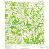
- USGS topographic map of Dellroy, OH, at 1:24000 scale. Heavier material. Waterproof. Tear-resistant. Foldable. Perfect for the outdoors.
- Cities, towns, villages: Tabor,Atwood Valley,Pines Cottage Area,Palermo-on-the-Lakes,Dellroy,Atwood Pines,Atwood Cove,Queensboro,Rockwood Park,Atwood Village,Atwood Crossing,Lakeview,Cove Cottage Area,Atwood (historical),Glenmar,Piney View,Leavittsville,Arrowhead,Valleyview,Grampian Hills,Paradise Point,Pine Hill,New Harrisburg
- Islands: Consult topo map preview for visible islands.
- Parks and forests: Leesville State Wildlife Area
Printed on Polypropylene
Shipping and Returns
- We offer tracked shipping on all orders. Tracking information will be shared as soon as the order is dispatched.
- Please check the delivery estimate before adding a product to the cart. This is displayed for every product on the website.
- Available shipping methods and charges will be displayed at the time of checkout, depending on your exact location.
- All customers are entitled to a return window of 14 days, starting from the date of delivery of the product(s).
- Customers are advised to read our return policy for details of the return process, eligibility, refunds as well as cancellations or exchanges.
- In case of any issues or concerns about Shipping or Returns, please contact us and we will be happy to help.
YellowMaps.
Dellroy OH topo map, 1:24000 Scale, 7.5 X 7.5 Minute, His...
£118.39
£197.32