
OUTDOOR TRAIL MAPS
Outdoor Trail Maps Taos Wilderness Areas - New Mexico Hiking (2023)
£42.94
£71.56
-
 Order within 6 hours and 42 minutes to get between July 4 - July 10
 -
 Tracked Shipping on All Orders
-
 14-Day Returns
- Secure Payments
-
 24/7 Customer Support
Description
- Waterproof, tear-resistant, 1:55,000 scale with a compact 4"x7" folded size for your pocket
- Smaller and lighter - under 2oz - no more unfurling huge maps - designed for on-trail use
- Segment distances - mileage - for all trails
- Up-to-date for 2023 with accurate trail routings and distances
- GPS coordinates for trailheads and trail junctions - device compatible
- 50 ft contour lines - with 250ft and 1000ft easy-to-ready index contours
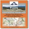
The Taos Wilderness Areas Topographic Hiking Map shows the trailheads and hiking trails of the Wheeler Peak Wilderness, Columbine-Hondo Wilderness, Latir Peak Wilderness and the northern portion of the Carson National Forest in northern New Mexico.
Shipping and Returns
- We offer tracked shipping on all orders. Tracking information will be shared as soon as the order is dispatched.
- Please check the delivery estimate before adding a product to the cart. This is displayed for every product on the website.
- Available shipping methods and charges will be displayed at the time of checkout, depending on your exact location.
- All customers are entitled to a return window of 14 days, starting from the date of delivery of the product(s).
- Customers are advised to read our return policy for details of the return process, eligibility, refunds as well as cancellations or exchanges.
- In case of any issues or concerns about Shipping or Returns, please contact us and we will be happy to help.
Outdoor Trail Maps.
Outdoor Trail Maps Taos Wilderness Areas - New Mexico Hik...
£42.94
£71.56