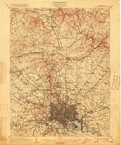
YellowMaps YellowMaps Baltimore MD topo map, 1:62500 Scale, 15 X 15 Minute, Historical, 1904, Updated 1915, 19.7 x 16.5 in - Tyvek
YellowMaps

YellowMaps Baltimore MD topo map, 1:62500 Scale, 15 X 15 Minute, Historical, 1904, Updated 1915, 19.7 x 16.5 in - Tyvek

Pseudo Checkbox Icon
Order within 0 hours and 0 minutes to get between -
Buying Bulk?
Delivery Truck IconTracked Shipping on All Orders Secure Payments
Headphones Icon 24/7 Customer SupportReturn Product Arrow Icon14 Days Returns
Description
  • Printed on Tyvek (synthetic)
  • USGS topographic map of Baltimore, MD, at 1:62500 scale. Lighter material. Waterproof. Tear-resistant. Foldable. Very durable. Perfect for backpacking and the outdoors.
  • Cities, towns, villages: Blenheim,Putty Hill,Valley Crest,Forest Park,Dulaney Village,Irvington,Marlywood,Edmondson Ridge,Lakeside,Blenheim Manor,Town and Country North,Dembeigh Hill,Idlewylde,Parkville Heights,Manor Hill,Anton Woods,Cedarcroft,Catonsville Heights,Eccleston,Glendale,Devonshire Forest,Charlestown,Brightside (historical),South Baltimore,Mount Winans,Valley North,West Hills,Ashland,Towson Estates,Dickeyville,Cedonia,Fullerton Heights,Patapsco Woods,Riverview (historical)
  • Mountains: Bare Hills,Federal Hill
  • Valleys: Green Spring Valley,Limekiln Hollow,Dulaney Valley