
Description
- Printed on Polypropylene (plastic)
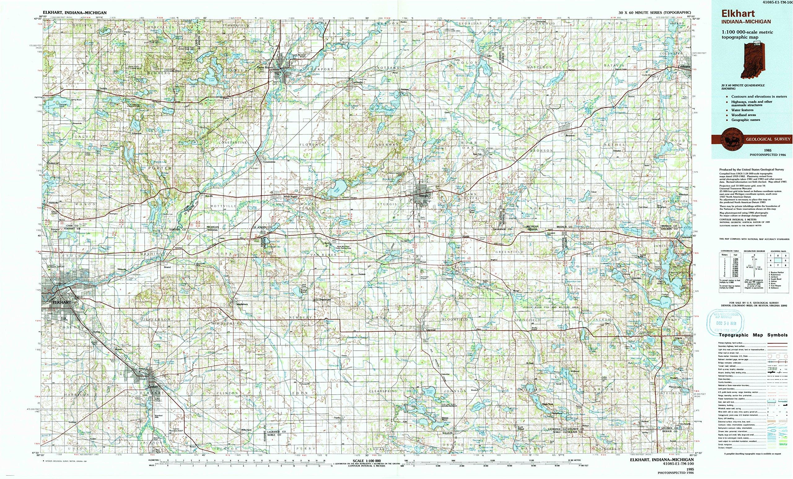
- USGS topographic map of Elkhart, IN, at 1:100000 scale. Heavier material. Waterproof. Tear-resistant. Foldable. Perfect for the outdoors.
- Cities, towns, villages: Centreville,Corey,Sturgis,Topeka,Northwood,Valentine,Batavia,Webers Landing,Panama,Honeyville,Oakwood,Flint,Moonlight,Salem Center,Millersburg,Three Rivers,Simonton Lake,Garden Village,Eddy,Elkhart,Valley Outlet Center,Plato,Star Mill,Greenwood,Matteson,Twin Lakes,Benton,Mount Pisgah,Nottawa,Midway,Middlebury,Lagrange,Brownsville,Coldwater,Wildwood,Pleasant Lake,Breezy Beach,Southwest,Waterford Mills,Woodland Park,Helmer,Fawn River,Scott,Jones,Gilead
- Islands: Brown Island,Deer Island,Memory Isle,Diamond Island,Eagle Island,Block Island
- Parks and forests: Oak Lawn Park,Pokagon State Park,Governor Cyrus Gray Luce Historical Marker,Harmon Field,Memorial Park,Palmer Lake Beach,Harry Blackstone Historical Marker,Cass County Park,Poe's Corners Historical Marker,Memory Isle Park,Chain Lake Baptist Church and Cemetery Historical Marker,Sue Silliman House Historical Marker,Harmon Park,Stewart House Historical Marker (historical),Langrick Street Park,Douglas Park,Moran Park,Meyer Broadway Park
USGS topographic map of Elkhart, Indiana, dated 1985, updated 1991.
Includes geographic coordinates (latitude and longitude), lines of elevation, bodies of water, roads, and more. This topo quad is suitable for recreational, outdoor uses, office applications, or wall map framing.
Printed on-demand by YellowMaps on the print material of your choice.
Shipping rolled from Minneapolis, MN, United States.
Product Number: USGS-5289140
Map Size: 24.1 inches high x 40 inches wide
Map Scale: 1:100000
Map Type: POD USGS Topographic Map
Map Series: HTMC
Map Version: Historical
Cell ID: 67471
Scan ID: 156815
Imprint Year: 1991
Woodland Tint: Yes
Photo Inspection Year: 1986
Aerial Photo Year: 1983
Edit Year: 1985
Datum: NAD27
Map Projection: Universal Transverse Mercator
Map published by United States Geological Survey
Map Language: English
Scanner Resolution: 600 dpi
Map Cell Name: Elkhart
Grid size: 30 X 60 Minute
Date on map: 1985
Geographical region: Indiana, United States
Northern map edge Latitude: 42
Southern map edge Latitude: 41.5
Western map edge Longitude: -86
Eastern map edge Longitude: -85
Surrounding map sheets (copy & paste the Product No. in the search bar):
North: USGS-5443614,USGS-5443732,USGS-5442970,USGS-5442968,USGS-5442966
East: USGS-5285954,USGS-5285952,USGS-5285950,USGS-5443522,USGS-5285956
South: USGS-5287222,USGS-5289148,USGS-5287224,USGS-5287220,USGS-5289146
West: USGS-5288624,USGS-5289192,USGS-5289194,USGS-5288628,USGS-5288626