
YELLOWMAPS
YellowMaps Fort Jackson North SC topo map, 1:24000 Scale, 7.5 X 7.5 Minute, Historical, 1953, Updated 1957, 26.8 x 22 in - Tyvek
£152.71
£254.52
-
 Order within to get between
 -
 Tracked Shipping on All Orders
-
 14-Day Returns
- Secure Payments
-
 24/7 Customer Support
Description
- Printed on Tyvek® (synthetic)
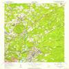
- USGS topographic map of Fort Jackson North, SC, at 1:24000 scale. Lighter material. Waterproof. Tear-resistant. Foldable. Very durable. Perfect for backpacking and the outdoors.
- Cities, towns, villages: Rockbridge,Weddell,Lakeview,Woodfield,Tanglewood,Woodfield Park,Wedgewood,Huntcliff,Springwood,Ravenwood,Brandywine,Lake Elizabeth Estates,Farrowoods,Kilbourne Heights,Forestwood Estates,State Park Acres,North Trenholm,Wildewood,Fairwold,Satchel Ford Terrace,Clear Springs,Williamsburg East,Charleswood,Kilbourne Park,Arcadia Lakes,Huntington,Folkestone,Sandwood,Richland,Foxhall,Spring Valley,Gregg Park,Springhill,Windsor Lake Park,Old Forest,East Lake Hills
- Mountains: Quinine Hill
- Valleys: Low elevation topographic features such as flatlands, river valleys, and canyons.
Printed on Tyvek
Shipping and Returns
- We offer tracked shipping on all orders. Tracking information will be shared as soon as the order is dispatched.
- Please check the delivery estimate before adding a product to the cart. This is displayed for every product on the website.
- Available shipping methods and charges will be displayed at the time of checkout, depending on your exact location.
- All customers are entitled to a return window of 14 days, starting from the date of delivery of the product(s).
- Customers are advised to read our return policy for details of the return process, eligibility, refunds as well as cancellations or exchanges.
- In case of any issues or concerns about Shipping or Returns, please contact us and we will be happy to help.
YellowMaps.
YellowMaps Fort Jackson North SC topo map, 1:24000 Scale,...
£152.71
£254.52